
Data Description
A full description of the data processing chain is given in the paper : Johnson, T.; Tsamados, M.; Muller, J.-P.; Stroeve, J. Mapping Arctic Sea-Ice Surface Roughness with Multi-Angle Imaging SpectroRadiometer. Remote Sens. 2022, 14, 6249. https://doi.org/10.3390/rs14246249
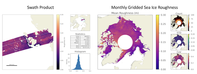
The data comes in two formats. First at individual swath level and second at monthly gridded level. The swath data are provided on the MISR native 1.1km SOM grid with block stitching applied and the monthly aggregates on a EASE-2 1km grid. All data are provided for the full Arctic north ~60N (MISR blocks 1-45) for the period 2000 to 2020 for April months. Each file is provided as hdf5 format.
Reference
If you use the MISR sea ice roughness data, please include the following acknowledgment: MISR Arctic sea ice roughness were provided by the Centre for Polar Observation and Modelling, Earth Sciences, University College London (www.cpom.ucl.ac.uk/misr_sea_ice_roughness), Reference: Johnson, T.; Tsamados, M.; Muller, J.-P.; Stroeve, J. Mapping Arctic Sea- Ice Surface Roughness with Multi-Angle Imaging SpectroRadiometer. Remote Sens. 2022, 14, 6249. https:// doi.org/10.3390/rs14246249
Data Access
Data Access Registration
To access the datasets, please provide your contact details so that we can notify you about any future updates.